
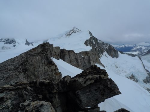
Cerro Caledonia
Page 3
Page 3


My thanks to The British Moutaineering Council, John Earle and Tom Barcham for all their help with this special feature
The British Mountaineering Council website
The British Mountaineering Council website
The Exploration of Tierra Del Fuego 1979
by John Earle
by John Earle
Punta Arenas - Chile
Back in our ice-fall camp, after a long and crevasse dodging descent, we discussed the possibility of the sheer North face of Roncagli that dominates the Dartmoor Glacier. There were two possibilities, one of which we jokingly called the Walker Spur after the Alpine counterpart. It started as a rock spur of some 2,500 feet, maybe more, then the route became steep ice and snow and finally ended in a snow covered rock wall before leading to the final huge cauliflowers of the ice-boss that made up the summit. A total of some 5,000 feet in all. Certainly a possible route in the Alps but no route of such technical difficulty had been attempted before in the Darwin Range and we all felt that we had not the equipment or indeed the overall expedition experience to tackle such a difficult climb.
Most of the problems might well come in the last 1,000 feet, where the winds could be hurricane force driving blinding snow storms. Until now the weather had been incredibly good to us and the others had not experienced the storms and wind, often lasting forty eight hours or more that I had with Eric Shipton. As if to prove the point, that night, severe guts hit our camp for several hours. Our two Ultimate tents, the "Tent and Pyramid stood the test and by dawn it was calm again.
We had seen, away to the north west of our camp, two high snow peaks and we now decided to carry out a reconnaissance towards them and explore that area.

To do this Iain Peters and I set out from our ice-fall camp and climbed steep ice and granulated snow through another complex area of seracs and crevasses. Eventually we reached a plateau of ice with outcrops of rock, still surprisingly very crevassed in an incredibly haphazard fashion. Quite close to the north west, we could see a small peak we had noticed from our moraine camp and we decided to make a first ascent of this as it would be a good vantage point.
The bad weather always seemed to hit us at about 4,000 feet and in strengthening wind, whipping stinging sleet at us; we climbed a long steep snow slope to reach a summit plateau with outcrops of rock. After lunch in a sheltered corner we climbed the final ice slope and rock tower to the summit. From Cerro Caledonia, 4,600 feet, named after our sponsors, we once again had the misery of realising that a way across to the two big snow peaks was impossible. Cerro Caledonia was part of a long ridge with three major peaks on it and the north side of this ridge dropped sheer for over 1,500 feet to another glacier that ran parallel to the Dartmoor glacier, which we named Ventisquero Armada de Chile. We could see that this glacier joined the Stoppani with the Roncagli and Cuevas glaciers. Our high snow peaks lay to the north of this glacier. Once again our way was baulked, but this is what exploratory mountaineering in an unknown area is all about. we were disappointed obviously, but at least we were fitting the pieces of the jigsaw together.
The bad weather always seemed to hit us at about 4,000 feet and in strengthening wind, whipping stinging sleet at us; we climbed a long steep snow slope to reach a summit plateau with outcrops of rock. After lunch in a sheltered corner we climbed the final ice slope and rock tower to the summit. From Cerro Caledonia, 4,600 feet, named after our sponsors, we once again had the misery of realising that a way across to the two big snow peaks was impossible. Cerro Caledonia was part of a long ridge with three major peaks on it and the north side of this ridge dropped sheer for over 1,500 feet to another glacier that ran parallel to the Dartmoor glacier, which we named Ventisquero Armada de Chile. We could see that this glacier joined the Stoppani with the Roncagli and Cuevas glaciers. Our high snow peaks lay to the north of this glacier. Once again our way was baulked, but this is what exploratory mountaineering in an unknown area is all about. we were disappointed obviously, but at least we were fitting the pieces of the jigsaw together.
An area of Serracs
The most westerly of the three peaks on the long ridge, was a fine looking snow and rock mountain above St. Valentines Col. It was clear that this should be our next objective. The easiest route up this mountain probably was to follow the Dartmoor glacier almost to the col and then strike up a long snow ridge with one section of seracs and crevasses.
Iain felt that because the crevasses on the glacier were in such a dangerous condition an approach to the peak could be made along the ridge from Cerro Caledonia. From our vantage point I felt the final section looked as if it might prove difficult, which indeed it did.
My twisted ankle had been giving me, increasingly, considerable pain (it often took twenty minutes to get the swollen foot into the boot) and it was with enormous regret that I had to make the decision that I could be a hindrance and even a hazard to the rest of the party when they set out to climb this peak. It was clearly going to be a long mountain day; any delay could have been disastrous. Iain recalls the climbing of the twin-headed summit of Pico Gemini 5,700 feet.
''We left the ice-fall camp at 9:15 am more with the idea of making the second ascent of Cerro Caledonia, and perhaps a reconnaissance of the approaches to the mountain rather than a serious attempt, as the weather had until then been doubtful with high winds and rainfall during the night. However as we climbed through the crevasses below the steep snow slopes leading up to the east ridge of Caledonia the sun came out and the weather improved dramatically inverse proportion to the snow which rapidly degenerated into damp loose granulated sugar.
After the summit of Caledonia, easy snow slopes led west for half mile or so until we reached the snow fields beneath our peak. By this time it had become obvious that given the good weather, we had a chance of climbing the mountain.
The rounded lumps of snow slopes leading up to the summit ridge, though technically easy, took up much time due to the conditions and it was not until one oclock that we found ourselves just one pitch below the ridge. There appeared two ways of overcoming the steep vertical snow wall above us. The first way was by an exposed traverse right to the edge of the northern cliffs of the mountain. I set forth on this, belayed by David who had buried himself in the Bergschrund, waist deep in snow. A few tentative steps soon convinced me of the impracticality and danger of this approach to the ridge. Melt water had frozen on the surface to give an impression of nice firm "front pointing ice, but in reality this was only a few inches thick and was supported by nothing. So we traversed down and left the steep seracs to a point where the cliffs eased to the vertical once more. I then led up steep soft exhausting snow for two pitches until it was possible to dig through to the summit ridge.
Unfortunately I then saw that the whole of this snow cliff was detached from the mountain and was in danger of avalanching. The others came up and in order to avoid the overhanging head wall guarding the summit, we made a long delicate traverse right, above another Bergschrund to a point where yet another sugar wall separated us from the slabs and rock walls leading to the summit. The snow on this second wall was even worse than we had encountered before. It was a case of vertical swimming and hoping that the ensuing trench did not avalanche. At the top of the pitch, I encountered thin snow on hold-less rock slabs. With crampons scrabbling uselessly I lay-backed up a detached block to a small stance and dubious delays. The rock above looked very unpromising but it led to a steep loose, easier ramp leading left and up towards the summit. However, after 150 feet it disappeared tantalisingly close to the top. By now it was five o'clock and the clouds had crept over the surrounding mountains and the wind had risen. We discussed retreat but also felt reluctant to go back, so close to the summit. I moved straight up with caution, as belays were illusory and reached the top via two awkward mantelshelves. As we gathered on the summit between the two ice crests, the wind strengthened and cloud closed in on us, but the three of us stood for the first time on the summit of Pico Gemini.
Having completed a considerable amount or exploratory mountaineering from our ice-fall camp: we moved back to our snug camp site on the moraine in a deep wooded glade, blocked at one end by views of Roncagli, with Guanaco drinking holes nearby and foxes so tame, that they trotted through the camp site on inquisitive visits and stole Dons plastic mug!
Time was now running short. Don and I had to get back to Puerto Williams about a week earlier than necessary to link up with a Lan Chile flight to Punta Arenas and then to Santiago. Yet another example of the timing not coinciding well. Iain and Dave needed at least ten days below the tree line to carry out their scientific work of seed collecting.
To tie up the final exploration of this area, Don and Dave climbed the third mountain at the east end of Cerro Caledonia ridge; a rock peak which they called Pico Sentinal, 4,700ft, as it guarded the entrance to the Dartmoor Glacier valley. Iain climbed another rock peak and ridge above our first Base Camp and descended to the Fox camp on the moraine. He called this Pico Condor because of the large numbers of the huge birds that he saw there and indeed we all saw at various stages of the expedition.
I found a way across the icy waters of the river that ran from the end of Dartmoor Glacier and reached the edge of the Stoppani Glacier and traversed across the cliffs above it, north west until I could satisfy myself that a route through existed to the Ventisquero Amada de Chile which in turn leads through to the glaciers in the interior of the Darwin Range. This is the way that future expeditions will have to go, if they wish to climb the big peaks to the north of the area where we are.
Iain and Don satisfied themselves that the ice-fall to the left of the big Rognon could be climbed, albeit as with all ice-falls - dangerously. This means that a way to the foot of the Walker Spur" of Roncagli is possible, at least this year.
Then it was almost over. A monstrous haul of huge loads, but at least in one journey, back to Base Camp. A couple of days spent helping Iain with his seed collecting, then we all set off with heavy loads down the ten miles to Yendegaia across the marsh with clouds of mosquitoes hanging round our heads. Dave and Iain stopped halfway to put up a camp near a likely stand of Nothafagus trees whilst Don and I continued to the Estancia.
Cerro Caledonia
Named after the expedition sponsors - British Caledonian
Cerro is Spanish for Mount or Mountain
Named after the expedition sponsors - British Caledonian
Cerro is Spanish for Mount or Mountain

The next day, Don and I had to make the twenty mile round journey to pick up the 6,000 feet of film I had shot, which had been left at our base Camp. It was a marvellous walk now that one was fir. I felt deeply reluctance to leave this wild and remote country, there was still so much to be done. It looked so gentle and peaceful in the warm sun and yet always there was the feeling that the mood could change in a minute.
How right I was. Tremendous winds shook and thundered at the frail wooden building of Estancia Yendegaia that night. When Don and I woke, it was still blowing a gale, and snow was down to 1,000 feet and sleet .was whipping across the bay.
We now had to walk the ten miles down the side of the bay to the Caribineros Post. Iain and Don, who had moved their camp further down the valley, joined us for this idyllic walk, thankfully to share the load carrying. In many ways it was like walking beside a Scottish Loch and for part of the time we actually walked along the beach, past mussel-covered rocks and kelp. After weeks in the mountains the smell, the sight and sound of the sea were delightful.
The Caribineros made us tremendously welcome with a huge steak tea and, almost more enjoyable, fresh lettuce, followed by a Birthday party with cake and one candle. One of the sergeants was thirty one.
They had radioed through to Puerto Williams and told them that we were here. So on the next day, Iain and Dave made their reluctant way, helped Im sure by an enormous steak butty, to their tent and dehydrated meals and seed collecting for at least another week. While Don and I in a semi-stunned state, were flown by helicopter back to Puerto Williams in fifty minutes. The splendid Chilean Navy at work again.
It was over too quickly. With hardly any time for readjustment, it left one feeling dissatisfied in a strange way. I needed time to step back and view it from a distance, to gather ones emotions, feelings and impressions and mould them into a coherent pattern. But one thing was clear; we had carried out extensive exploration in a remote and difficult area and have linked the known with the unknown.
It was an expedition I think that Eric Shipton would have enjoyed.