
Cerro Caledonia
Page 2
Page 2


My thanks to The British Moutaineering Council, John Earle and Tom Barcham for all their help with this special feature
The British Mountaineering Council website
The British Mountaineering Council website
The Exploration of Tierra Del Fuego 1979
by John Earle
by John Earle
Punta Arenas - Chile
We then flew down to the far side of the bay, to the Caribineros Post of Dos de Mayo to make further arrangements-for the loan of two extra horses. Within a couple of hours we were back in Puerto Williams having dropped in at Puerto Navarino for tea! Such is travel by helicopter. This was the Chilean Navy with all the stops out!
We still had to spend a few days near Puerto Williams camping some five miles away at the MacLeans crab canning factory. Iain and Don took advantage of this by undertaking a fifteen hour journey to reach the Teeth of Navarino, an exciting and impressive line of rocky summits nine miles or so inland, not unlike Chamonix Aiguille but with rock certainly not of the same quality. They managed to make first ascents of two of them on their long day.
We still had to spend a few days near Puerto Williams camping some five miles away at the MacLeans crab canning factory. Iain and Don took advantage of this by undertaking a fifteen hour journey to reach the Teeth of Navarino, an exciting and impressive line of rocky summits nine miles or so inland, not unlike Chamonix Aiguille but with rock certainly not of the same quality. They managed to make first ascents of two of them on their long day.
I also made an ascent of a 3,000 foot peak nearer the Beagle Channel having first spent several hours filming the rare Torrent or Waterfall duck and beaver dams in the forests.
In the event Patrick Maclean was not able to take us to Yendegaia as the gear box on the crabbing boat had broken, but we had been made most welcome at the factory, by Mario, Patrick and their workers alike. So it was the Chilean Navy that once again sprang to our help by taking the four of us, our equipment and food in a landing craft.
We left at midnight, slipping out into the inky black Beagle Channel under the Southern Cross. By first light we were off Yendegaia. After breakfast of newly baked bread in the Ward Room, Lieutenant Alfonso Wenzel, whose first command this was, took the vessel in close to a rough stone quay. It was a highly skilful manoeuvre which demanded holding the landing craft in position by a stern anchor. The ramp was lowered and we made our "Commando raid onto the land. Iain remained on board to land later at the Caribineros Post to help bring round the extra horses.
The next day looking like a motley cavalry made up of Don Quixote, Sancho Panza and the White Knight, we set off up the huge flat alluvial plain for the tem miles to the Stoppani Glacier. It was raining heavily most of the time and several stops were needed to retie the slipping kit bags that contained the food and equipment.
After five hours we reached the glacier and pitched Base Camp at about 400 feet, at the foot of a steeply wooded gully, in a sheltered corner at the edge of a forest, that rose up like a jungle for over 1000 feet behind us. With no shortage of food, we had a fire going and a brew ready before the two shepherds who had guided us here, returned to the Estancia. Later that evening, as we sat by the huge fire, it seemed hard to realise that we were here at last and for me the dream had become a reality.
Our first problem was to move our supplies in as easily as possible to the mountains. Clearly the Stoppani glacier itself was impossible. It was a grotesque maze of huge, open crevasses running for many miles to the north west. At this point the fast flowing glacial river ran along the edge of the ice on the true right bank of the glacier, below great mounds of lateral moraine and ice smoothed cliffs. Was there a way we could get along partly on the moraine, partly on the beach and partly by climbing over the smooth slabs? From now on our exploratory mountaineering started into this unknown area.
It had rained for twenty four hours and was still raining when we set out to try to find a way beside the glacier that led to the side valley we wished to follow towards Roncagli. We were able to turn every difficulty either by following the river Beach, or traversing along smooth rocks above; a tortuous route of loose boulders, moraine and polished rock winding up for some three miles. The outcome was uncertain to the end and it was with mounting excitement that we were able to turn west and discover the glacial lake we expected to find below the terminal moraine that we eventually called the Dartmoor Glacier. The lake itself might have caused a problem but once again there was a way across steep slabs for about a quarter of a mile, just above the water that got us to the marsh beyond. Well pleased with out first reconnaissance we trudged through the rain back to Base Camp.
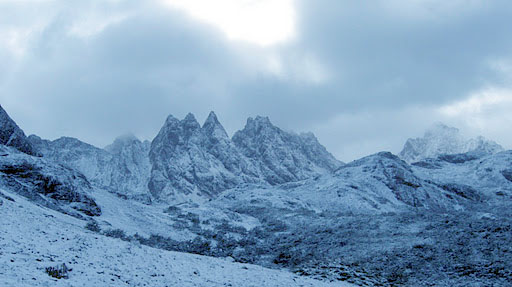
Dientes de Navarino / The Teeth of Navarino
The next day we carried some twenty, four-man day rations by the same route to the far end of the marsh, beyond the lake to below the huge wooded terminal moraine of the Dartmoor Glacier. We dumped our loads and climbed 300 feet to the top of the moraine and looked for the first time at the glaciers and peaks we had come to explore, including an impressive and difficult sheer, 5,000 feet face of rock and ice of a mountain that could only be Roncagli. Running along the crest of the lateral moraine was a well defined track and indeed we had followed a section of track on the previous part of our route.
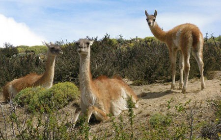
From my earlier trip with Eric Shipton I knew that these tracks were made by Guanaco (left) and we were to bless them and their innate route finding skills many times in the next few weeks. Later we saw and indeed came very close to these shy and inquisitive creatures often with young. Thankfully they are not hunted in this remote area.
From my earlier trip with Eric Shipton I knew that these tracks were made by Guanaco (left) and we were to bless them and their innate route finding skills many times in the next few weeks. Later we saw and indeed came very close to these shy and inquisitive creatures often with young. Thankfully they are not hunted in this remote area.
The time had now come to leave our idyllic Base Camp and once with huge loads we managed to get all we needed for the next phase of the exploration as far as the Lake Guanaco Camp where we had dumped the food the previous day. It was at this stage that I had the great misfortune to turn my right ankle over, (x-rays later showed a fracture) trying to hurry after the others with a 70lb pack on my back to take more shots for the television film that I was making.
The Guanaco track on the moraine led us for three miles beside the glacier towards Roncagli. It was quite extraordinary walking on the ridge. To our left and below us was the dense forest, Darwins temperate jungle. While on our right was the glacier and moraine, a world of ice and rock. The contrast was astonishing. For this section we had to relay the loads, an exhausting and boring business but we were able to establish a camp at the far end of the moraine, still in the trees where we could use wood for fuel.
From this camp we carried out a reconnaissance across the glacier below the Rognon that divides the Dartmoor Glacier. we wanted now to see if there was a way to the upper part of the glacier and up to a col which we reckoned was the route to the supposedly easier west side of Roncagli.
There seemed two possibilities. One was to try to find a direct way up a 500 foot ice-fall. The other was to try to find a longer way round the far end of the ice-fall.

We moved first into the chaotic jumble of rotten ice towers and blocks of the main part of the ice-fall. The temperatures were well above freezing and we were, after all, still only about 2,000 feet high. All my instincts told me this was a dangerous and foolhardy place to be. We climbed easily for 200 feet or so but as the route became more difficult and we heard the sound of a considerable avalanche of ice blocks quite close to where we were, we had no difficulty in making the decision that this was not a safe way. We cramponed and front-pointed our way down as if every step was booby-trapped. Later we often watched ice avalanches sweep the route we had taken.
Before we could try the other alternative, reluctantly we now had to leave the morale boosting comfort of huge wooden fires at the moraine camp. The next stage was to double load our food and equipment onto the glacier and make a camp there, at what we hoped was a safe distance from the ice-fall.
It was a good camp at 2,000 feet, well sheltered from the prevailing winds but we were constantly reminded that we were on a glacier, not only by the cold striking up through the our sleeping bags at night, but by the creaks and cracks as the glacier inched ion its way and by the sound of collapsing ice blocks thundering down the ice-fall only a few hundred yards away.
A frozen waterfall or Ice fall
The next part of the exploration jigsaw to be fitted into place was the col at the far end of the glacier. The weather at this stage was unbelievably good for the Darwin Range. Almost every day started out sunny and calm but with clouds, snow and wind arriving by mid-afternoon. So it was on a fine morning we set off to try the second way up the ice-fall. We climbed steeply behind our camp through a series of crevasses to a broad snow field that in turn steepened towards a corner, where it looked as if a ramp ran through the crevasses to the area above.
This proved possible and by a fairly complicated route we were through the main difficulties. However we were now faced with appalling snow conditions that were to endanger us for the rest of the expedition. The rain, coupled with the exceptionally dry and warm summer made the snow very soft and granular. We expected there to be few crevasses on this higher area of glacier, but it was, instead, and incredibly complex and heavily crevassed section and all the snow bridges were soft. Each one of us had to be belayed over the obvious. Dangerous sections and we had to proceed with extreme care ready to plunge our ice-axe into the soft snow if anyone fell into a crevasse.
None of us fell completely into a crevasse but we all had the unnerving experience of breaking in up to our waists with our legs dangling in space over the blue and green icy depths below.
By lunch time the weather had worsened to squalls and sleet but it was vital to get to the col. All the decisions for the rest of our exploration depended on what we found there.
The visibility was down to about a quarter of a mile and the wind had strengthened considerably, blowing stinging sleet as we climbed on, but at last the glacier flattened, the crevasses vanished and ahead we could see the narrow col between a steep rock ridge on the left and steep ice on the right. We had made it. February 14th, so obviously it had to be St. Valentines Col, about 4,000 feet.
In spite of the elation of reaching this unknown col, our disappointment was intense. Instead of a link through to the great glaciers of the interior of the Darwin Range, the Roncagli glacier that runs south west to the Beagle Channel and the Cuevas glacier that runs north west to Parry Bay, the far side of the col, was a sheer drop of over a 1,000 feet of rotten ice and loose snow-covered rock.
There, far below us, were those glaciers we had hoped to explore. Even if we had been able to get ourselves down, the task of getting heavy loads of food and equipment to the glaciers below would have been virtually impossible especially in the limited time we had.
Worse still we could see also that instead of the easier snow slopes we had expected on the north west and west of Roncagli, once again these were sheer difficult looking buttresses and long snow-covered rock ridges.
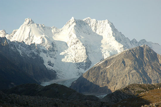
Roncagli